


Handy GPS lite

คำอธิบายของHandy GPS lite
คู่หูที่สมบูรณ์แบบสำหรับการผจญภัยกลางแจ้งครั้งต่อไปของคุณ ค้นหา ค้นหา บันทึก และกลับบ้านด้วย Handy GPS ไม่จำเป็นต้องมีบัญชีผู้ใช้หรือการตั้งค่า - เพียงแค่ติดตั้ง เปิด GPS ของคุณแล้วไปได้เลย!
แอปนี้เป็นเครื่องมือนำทางที่ทรงพลังซึ่งออกแบบมาสำหรับกีฬากลางแจ้ง เช่น การเดินป่า การเดินป่า การเดินป่า ปั่นจักรยานเสือภูเขา พายเรือคายัค ขี่ม้า และ geocaching นอกจากนี้ยังมีประโยชน์สำหรับการสำรวจ เหมืองแร่ โบราณคดี และงานป่าไม้ ใช้งานง่ายและทำงานได้แม้ในพื้นที่ทุรกันดารห่างไกล เนื่องจากไม่ต้องใช้การเชื่อมต่อเครือข่าย ช่วยให้คุณทำงานในพิกัด UTM หรือละติจูด/ละติจูดได้ คุณจึงสามารถใช้กับแผนที่ภูมิประเทศแบบกระดาษของคุณได้
หมายเหตุ: นี่เป็นรุ่นทดลองใช้ฟรีและจำกัดการจัดเก็บเพียง 3 จุดอ้างอิง และ 40 จุดติดตามบันทึก คุณสามารถใช้เวอร์ชันทดลองได้นานเท่าที่คุณต้องการ แต่หากคุณชอบแอปนี้ โปรดติดตั้ง "Handy GPS" เวอร์ชันที่ต้องชำระเงินเพื่อรับเวอร์ชันไม่จำกัดพร้อมฟีเจอร์อื่นๆ อีกมากมาย ขอบคุณ!
นอกจากนี้ อนุญาตให้แอปใช้ GPS ตลอดเวลา และปิดการเพิ่มประสิทธิภาพแบตเตอรี่เพื่อให้แอปบันทึกแทร็กล็อกที่เชื่อถือได้เมื่อปิดหน้าจอโทรศัพท์
คุณสมบัติพื้นฐาน:
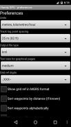
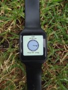
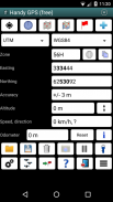
* แสดงพิกัดปัจจุบันของคุณ ระดับความสูง ความเร็ว ทิศทางของการเดินทาง และระยะทางทั้งหมดที่เดินทางในหน่วยเมตริก จักรวรรดิ/สหรัฐอเมริกา หรือหน่วยทะเล
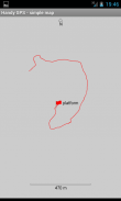
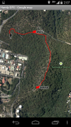
* สามารถจัดเก็บตำแหน่งปัจจุบันของคุณเป็นจุดอ้างอิง และบันทึกเส้นทางเพื่อแสดงตำแหน่งที่คุณเคยไปบนแผนที่
* สามารถนำเข้าและส่งออกข้อมูลไปยังไฟล์ KML และ GPX
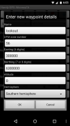
* อนุญาตให้ป้อนจุดอ้างอิงด้วยตนเองในพิกัด UTM, MGRS และ lat/lon
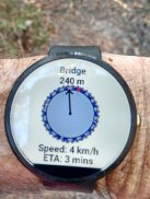
* สามารถนำทางคุณไปยังจุดอ้างอิงโดยใช้หน้าจอ "Goto" และเลือกที่จะส่งเสียงเตือนเมื่อคุณเข้าใกล้
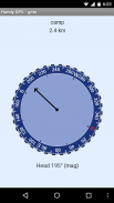
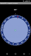
* มีหน้าเข็มทิศที่ทำงานบนอุปกรณ์ที่มีเซ็นเซอร์สนามแม่เหล็ก
* คำนวณ geoid offset ในพื้นที่โดยอัตโนมัติเพื่อปรับปรุงความแม่นยำในระดับความสูง
* รองรับ Datum WGS84 ทั่วโลกพร้อมกับ Datum ทั่วไปของออสเตรเลียและกริดแผนที่ คุณสามารถใช้ WGS84 สำหรับแผนที่ NAD83 ในสหรัฐอเมริกาได้
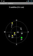
* แสดงตำแหน่งดาวเทียม GPS และความแรงของสัญญาณแบบกราฟิก
* สามารถแสดงการอ้างอิงตารางอย่างง่ายหรือ MGRS
* สามารถคำนวณระยะทางและทิศทางของ Waypoint-to-waypoint
* รวมสายจับเวลาเสริมเพื่อบันทึกระยะเวลาเดินและคำนวณความเร็วเฉลี่ยของคุณ
* ผ่านการทดสอบอย่างละเอียดโดยผู้พัฒนาในการเดินนอกเส้นทางหลายครั้ง
คุณสมบัติพิเศษเฉพาะในรุ่นที่จ่าย:
* ไม่มีโฆษณา
* จุดอ้างอิงและจุดติดตามไม่ จำกัด จำนวน
* แผนที่ออฟไลน์
* Datums ที่กำหนดเอง
* โปรไฟล์ระดับความสูง
* ถ่ายภาพและบันทึกเสียงบันทึกจากแอพ
* ส่งอีเมลหรือส่ง SMS ตำแหน่งของคุณให้เพื่อน
* การอ้างอิงกริดของสหราชอาณาจักร
* ค่าเฉลี่ย GPS เพื่อปรับปรุงความแม่นยำของตำแหน่ง
* พระอาทิตย์ขึ้นและตั้งเวลา
* ส่งออกจุดอ้างอิงและแทร็กล็อกเป็นไฟล์ CSV
* โครงการจุดโดยใช้แบริ่งและระยะทาง
* การคำนวณความยาว พื้นที่ และการเปลี่ยนแปลงระดับความสูงจาก tracklog
* คำนวณแคลอรี่
สิทธิ์: (1) GPS - เพื่อระบุตำแหน่งของคุณ (2) การเข้าถึงเครือข่าย - สำหรับการเข้าถึงเลเยอร์แผนที่มาตรฐานและไทล์ OSM (3) การเข้าถึงการ์ด SD - เพื่อโหลดและจัดเก็บจุดอ้างอิงและแทร็กล็อก (4) การเข้าถึงกล้องสำหรับการถ่าย pics*, (5) ป้องกันไม่ให้โทรศัพท์เข้าสู่โหมดสลีปเพื่อให้สัญญาณเตือนระยะใกล้ทำงาน (6) ควบคุมไฟฉาย เพื่อให้เปิด/ปิดไฟฉายได้จากภายในแอพ (7) บันทึกเสียงสำหรับบันทึกเสียง* (* ฟีเจอร์มีเฉพาะในแอปเวอร์ชันเต็มเท่านั้น)
การปฏิเสธความรับผิด: คุณใช้แอพนี้ด้วยความเสี่ยงของคุณเอง ผู้พัฒนาไม่รับผิดชอบต่อการสูญหายหรือได้รับบาดเจ็บอันเป็นผลมาจากการใช้แอพนี้ แบตเตอรี่ในอุปกรณ์พกพาอาจหมดได้ สำหรับการเดินป่าระยะยาวและระยะไกล ขอแนะนำให้ใช้แบตเตอรี่สำรองและวิธีการนำทางอื่นๆ เช่น แผนที่กระดาษและเข็มทิศเพื่อความปลอดภัย
Handy GPS lite--เวอร์ชั่น42.8
(21-11-2024)
Handy GPS lite - ข้อมูล APK
เวอร์ชั่น APK: 42.8แพ็คเกจ: binaryearth.handygpsfreeเวอร์ชั่นล่าสุดของHandy GPS lite
เวอร์ชั่นอื่น


 3.78
3.78


แอปในประเภทเดียวกัน

คุณอาจจะชอบ...


